|
|||||||||||||||
History
Norsewood is located in the heart of what was once the dense and towering forest known as the Seventy Mile Bush. The town was established in 1872, with the arrival of 372 Norwegians and 11 Swedes aboard the Norwegian ship Høvding, at Napier on 15 September 1872. The same day, the English ship Ballarat also arrived at Napier, its passengers including around 70 Danes. Høvding arrived again at Napier on 1 December 1873, this time with 369 Norwegians - bringing all together 752 immigrants on the two journeys. Most of these people became Norsewood's pioneer settlers. The remainder fulfilled the same role at the bush settlement of Dannevirke, some 22 kilometres away.
Norsewood's situation on State Highway 2 brought the town to predominance again with the rise in car use. The re-alignment of the highway in 1966 divided Norsewood into the "Upper" and "Lower" halves. Now travellers only see signs and the bridge joining the two halves as they travel on the highway. |


Tidbits
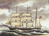 |
Hovding Left is a painting of the Norwegian ship Hovding, after its subsequent conversion to a barque. It brought two large contingents of Norwegian settlers bound for Norsewood (and some for Dannevirke) in 1872 and 1873. Contrary to some claims, these two voyages involved the same ship but with different captains - the first having been accidentally killed during the trip back to Norway after the 1872 voyage. Click on the image for a larger version. |
 |
Historic Kahikitea Tree and its Sign This Kahikitea tree in Kopua Road is a remnant of the original forest in the district. Once the Seventy Mile Bush was covered with trees like it - and much larger versions of it. ANZAC Park, previously known as the Norsewood Domain, can be visited to get a sense of what the bush in the area was like. The tree's sign tells of some of the early history of the settlement, you can read it here . |
 |
Scandi-wheel The Scandi-wheel imagery appears throughout Norsewood. This wheel with a square inside was invented by the New Zealand settlers for use in the forest. The spokes of normal, less sturdy wheels broke all too frequently in the rough forests so this unique wheel came in great use to the settlers for clearing the forest. |
 |
Norsewood Cemetery Norsewood Cemetery, on Ngamoko Road, is possibly the largest predominantly New Zealand Cemetery in Australasia. The first burial occurred there within weeks of the first settlers arriving in 1872, with the death of a small child. For more information on the Norsewood Cemetery visit the Norsewood Cemetery site . |
 |
Memorial to the Early Settlers An oak tree was planted on the corner of Coronation Street and Ngamoko Road on 20th September 1897 to celebrate 25 years since Norsewood's settlement. A monument was added to the site for the 50th anniversary and another plaque for the 60th. Unfortunately, the oak had to be replaced in 1975 with another oak from the same stock as the original. |
Articles
The NZ Farmer, Bee & Poultry Journal, June 1898 - Norsewood Dairy Factory Dannevirke Advocate, January 1902 - The Beck Boer War Memorial |